- Page d'accueil /
- Électronique /
- Électronique pour voitures et véhicules /
- Marine Electronics /
- Marine GPS Chartplotters /
- Weems & Plath Marine Navigation GPS Plotter
0 ratings

Numéro d'article:
25178446
Weems & Plath Marine Navigation GPS Plotter
Numéro d'article:
25178446
XAF 58760
Price Details
Excluding Shipping & Custom charges ( Shipping and custom charges will be calculated on checkout )
*All items will import from États-Unis
0 ratings
Écrire un commentaire
En stock
QTY:
Commandez maintenant et recevez votre commande aux alentours du Sunday, Juin 28
Transaction sécurisée
Ubuy s'engage à protéger votre sécurité et votre confidentialité. Notre système avancé de sécurité des paiements garantit la confidentialité en chiffrant vos informations lors de la transmission grâce aux protocoles AES (Advanced Encryption Standards) et SSL (Secure Socket Layer). Vos coordonnées de paiement sont 100 % sécurisées car nous ne partageons pas vos informations de paiement avec des vendeurs tiers.
nos meilleurs partenaires logistiques
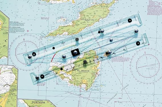
Quickly, easily, and accurately plot your GPS coordinates on a paper chart with our GPS Plotter.
Livraison
rapide
Retour
gratuit*
Emballage sécurisé
Produits 100 % originaux
Conformité PCI DSS

Certifié ISO 27001
Note: Step Down Voltage Transformer required for using electronics products of États-Unis store (110-120). Recommended power converters Acheter maintenant.


Détails du produit
| Item Weight | 1.5 lbs (680 grams) |
DESCRIPTION DU PRODUIT
Weems & Plath Marine Navigation GPS Plotter
Vous avez une question ? Chattez avec nous
Questions et réponses des clients
-
question:
What features does the Weems & Plath Marine Navigation GPS Plotter offer?
répondre: The Weems & Plath Marine Navigation GPS Plotter boasts advanced features such as precise GPS tracking, easy-to-read display options, and customizable waypoints. Designed for marine navigation, this plotter helps sailors navigate with confidence by providing clear maps and real-time positioning data. With integrated tools for route planning, users can chart their course effectively, making it a valuable asset for both recreational boaters and professional mariners. -
question:
Is the Weems & Plath Marine Navigation GPS Plotter user-friendly?
répondre: Yes, the user interface of the Weems & Plath Marine Navigation GPS Plotter is designed to be intuitive and accessible even for novice users. The touch screen feature allows for easy navigation through menus and settings, which is essential when out at sea. This GPS plotter has customizable display options, making it suitable for various lighting conditions, and ensuring that all users can operate it with minimal training. -
question:
Can the Weems & Plath GPS Plotter provide real-time weather updates?
répondre: The Weems & Plath Marine Navigation GPS Plotter does not inherently provide real-time weather updates; however, it can integrate with compatible devices or apps that do. The importance of weather conditions cannot be overstated in marine environments, and by connecting to weather services, users can monitor changes and make informed decisions during their voyages, enhancing safety on the water. -
question:
What types of maps does the Weems & Plath GPS Plotter support?
répondre: The Weems & Plath Marine Navigation GPS Plotter supports various maritime map types, including vector charts and raster charts. This flexibility ensures users can access the most relevant and up-to-date navigational information for their specific sailing area. Many boaters prefer vector charts for their accuracy and detail, while raster charts provide historical data, catering to diverse navigational needs. -
question:
How does the Weems & Plath GPS Plotter assist in route planning?
répondre: The Weems & Plath Marine Navigation GPS Plotter simplifies route planning by allowing users to set waypoints and create paths directly on its interface. The plotting software can calculate the distance and estimated travel time, enabling sailors to plan their journeys more effectively. This capability is crucial for long-distance voyages, where precise navigation can make all the difference in safety and efficiency. -
question:
What is the battery life of the Weems & Plath Marine Navigation GPS Plotter?
répondre: The battery life of the Weems & Plath Marine Navigation GPS Plotter is designed to support extended use without interruption. While specifics can vary based on operational settings, users typically find the battery performs well for prolonged periods, making it suitable for day trips or longer excursions. Ensuring that the device is adequately charged before setting out is essential for continuous navigation and access to critical information while on the water. -
question:
Can I use the Weems & Plath GPS Plotter for both inland and offshore navigation?
répondre: Yes, the Weems & Plath Marine Navigation GPS Plotter is versatile enough for both inland and offshore navigation. Its comprehensive mapping capabilities allow users to navigate various waterways confidently. This multifunctionality makes it ideal for recreational boaters who explore lakes and rivers as well as for those sailing in coastal environments, ensuring reliable performance in diverse settings. -
question:
Does the Weems & Plath GPS Plotter support Bluetooth connectivity?
répondre: The Weems & Plath Marine Navigation GPS Plotter typically does not include Bluetooth connectivity, focusing instead on providing reliable GPS navigation without additional wireless features. Nonetheless, it can connect to external devices such as AIS transponders for better situational awareness. This ensures that every boater has the tools needed to stay informed about other vessels in the vicinity while navigating. -
question:
Are updates available for the Weems & Plath Marine Navigation GPS Plotter?
répondre: Yes, users can access updates for the Weems & Plath Marine Navigation GPS Plotter to enhance functionality and support newer navigation technologies. Keeping the software up to date is crucial for ensuring optimal performance and access to the latest maritime charts. Regular updates can improve features and provide usability enhancements, making it a reliable tool for any maritime journey. -
question:
Where can I buy the Weems & Plath Marine Navigation GPS Plotter in Gabon?
répondre: You can purchase the Weems & Plath Marine Navigation GPS Plotter in Gabon at Ubuy. Ubuy offers a reliable online platform where you can find this product and have it delivered straight to your location, ensuring easy access for all your navigation needs.
WEEMS&PLATH Marine GPS Chartplotters Editorial Review
The Weems & Plath Marine Navigation GPS Plotter offers a great concept, but falls short in terms of construction quality. The arms and hinge points that establish the parallels are flimsy and fail to maintain accurate navigation. Although it is good enough for general area navigation, it is not suitable for specific location accuracy. Some units have arrived with missing support-feet and slight twists, while others have issues with misaligned ruler markings and unreadable instructions. The responsibility for these faults lies with the manufacturer, Weems & Plath, as the quality of their packaging and the misaligned markers are a result of their Q&A department. Despite these flaws, the product functions as listed and some customers would consider buying it again.
Avis et évaluations clients
1 évaluations des clients
-
5 étoile
0%
-
4 étoile
100%
-
3 étoile
0%
-
2 étoile
0%
-
1 étoile
0%
Donnez votre avis sur ce produit
Partagez votre avis avec d'autres clients
Avantages
- Great concept
- Functions as listed
- Arrived on time
Les inconvénients
- Flimsy construction
Historique des prix du produit
Informations importantes
- Limitations : Pour les produits expédiés à l'international, veuillez noter que toute garantie du fabricant peut ne pas être valide ; les options de service du fabricant peuvent ne pas être disponibles ; les manuels, instructions et avertissements de sécurité des produits peuvent ne pas être dans les langues du pays de destination ; les produits (et les matériaux qui les accompagnent) peuvent ne pas être conçus conformément aux normes, spécifications et exigences d'étiquetage du pays de destination ; et les produits peuvent ne pas être conformes à la tension et aux autres normes électriques du pays de destination (nécessitant l'utilisation d'un adaptateur ou d'un convertisseur le cas échéant). Il incombe au destinataire de s'assurer que le produit peut être importé légalement dans le pays de destination. En cas de commande auprès d'Ubuy ou de ses filiales, le destinataire est l'importateur officiel et doit se conformer à toutes les lois et réglementations du pays de destination.
- Tous les produits listés sur Ubuy ne sont pas à vendre, Ubuy étant un moteur de recherche mondial. Les produits sont soumis aux réglementations en matière d'exportation et de commerce.
XAF 58760
Commandez maintenant et recevez votre commande aux alentours du Sunday, Juin 28
This item is not restrict in my country.(Please click on above link if this item is not restrict in your country, So our team will review and allow.)
QTY:
Transaction sécurisée
Ubuy s'engage à protéger votre sécurité et votre confidentialité. Notre système avancé de sécurité des paiements garantit la confidentialité en chiffrant vos informations lors de la transmission grâce aux protocoles AES (Advanced Encryption Standards) et SSL (Secure Socket Layer). Vos coordonnées de paiement sont 100 % sécurisées car nous ne partageons pas vos informations de paiement avec des vendeurs tiers.
nos meilleurs partenaires logistiques
Livraison transfrontalière la plus rapide
Caractéristiques et avantages
- Simplified two-step maneuver for plotting GPS coordinates.
- Compatible with any paper chart for versatile use.
- Designed for accuracy in latitude and longitude plotting.
- User-friendly interface for anyone, regardless of experience.
- Enhances traditional navigation methods with modern technology.
- Essential tool for sailors and outdoor enthusiasts.